


[PICTORIAL MAPS – TRAVEL]. Three Pictorial Maps. 1940s/50s....
Similar Sale History
View More Items in Maps & Atlases![[PICTORIAL MAPS]. Six travel maps and brochures. Includes: ...: [PICTORIAL MAPS]. Six travel maps and brochures. Includes: RENTSCHLER, F. Historical Map of the Old Northwest Territory. 1937. New York: Farrar and Rinehart Inc. 23 x 17 ¼”. Folded. Stored](https://p1.liveauctioneers.com/928/305275/163151901_1_x.jpg?height=310&quality=70&version=1697054833)


![1888 Tunnison Pictorial Representation of Means of: Title/Content of Map: 1888 Tunnison Pictorial Representation of Means of Travel [verso] Russia in Europe -- How the World Travels [verso] Tunison's Russia in Europe Date: 1888, Jacksonville, Illinois](https://p1.liveauctioneers.com/5584/128489/65352496_1_x.jpg?height=310&quality=70&version=1538523113)


Related Maps & Atlases


More Items in Maps & Atlases
View More


![[MAP]. TODESCHI, Pietro. [Nova et Acurata Totius Americae Tabula auct. G.I. Blaeu] America quarta: [MAP]. TODESCHI, Pietro. [Nova et Acurata Totius Americae Tabula auct. G.I. Blaeu] America quarta pars orbis quam plerunq, nuvum orbem appellitant primo detecta est anno 1492 a Christophoro Columbo...](https://p1.liveauctioneers.com/197/329395/177650542_1_x.jpg?height=310&quality=70&version=1715364962)

![[MAPS]. HOMANN, Johann Baptist, HOMANN HEIRS, and Georg Matthäus SEUTTER. [Composite Atlas].: [MAPS]. HOMANN, Johann Baptist (1663-1724), HOMANN HEIRS, and Georg Matthäus SEUTTER (1678-1757). [Composite Atlas]. [Nuremberg, Augsburg, and others: Homann Heirs and others, maps dated between](https://p1.liveauctioneers.com/197/329395/177650530_1_x.jpg?height=310&quality=70&version=1715364962)


![[MAP]. ORTELIUS, Abraham. Americae Sive Novi Orbis, Nova Descriptio. 1573.: [MAP]. ORTELIUS, Abraham (1527-1598). Americae Sive Novi Orbis, Nova Descriptio. Antwerp, 1573. Engraved map with hand-coloring. Framed and double glazed, visible area 375 x 521 mm (unexamined out of](https://p1.liveauctioneers.com/197/329395/177650534_1_x.jpg?height=310&quality=70&version=1715364962)


![[MAP]. ORTELIUS, Abraham. Turcici Imperii Descriptio.1592.: [MAP]. ORTELIUS, Abraham (1527-1598). Turcici Imperii Descriptio. Antwerp, 1592. Engraved map with hand-coloring. Matted, framed, and double glazed, sight 406 x 521 mm (unexamined out of frame). Decor](https://p1.liveauctioneers.com/197/329395/177650538_1_x.jpg?height=310&quality=70&version=1715364962)

Recommended Transportation & Travel Collectibles
View More


![[FLAGS]. 31-star American parade flag. Ca 1850-1859.: [FLAGS]. 31-star American parade flag. Ca 1850-1859. 22 x 36 1/2 in. cotton flag with 31 printed stars, configured in a double medallion surrounding a much larger central star, that is haloed in both](https://p1.liveauctioneers.com/197/329785/177758218_1_x.jpg?height=310&quality=70&version=1715625218)


![[PICTORIAL MAPS – TRAVEL]. Three Pictorial Maps. 1940s/50s....](https://p1.liveauctioneers.com/928/325952/175495561_1_x.jpg?quality=1&version=1712935174&width=486)
![[PICTORIAL MAPS – TRAVEL]. Three Pictorial Maps. 1940s/50s....](https://p1.liveauctioneers.com/928/325952/175495561_1_x.jpg?quality=80&version=1712935174)
Item Details
Description
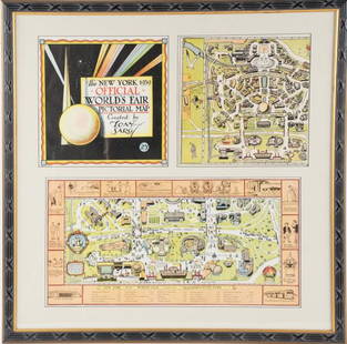
[PICTORIAL MAPS – TRAVEL]. Three Pictorial Maps. 1940s/50s. Three brochure sized foldout maps designed for travel including: Highroads to Happiness. Mexico City: Pemex Travel Club, ca. 1940s. – A New Map of Cincinnati Historic & Pictorial Pleasure Map of America. Cincinnati: Cincinnati Pictorial Map Co., 1940. – BUSH, M.E. Pleasure Map of America. United States: Greyhound Highway Tours, Inc., 1954. Largest 18” x 28”. Condition generally A.
Buyer's Premium
- 25%
[PICTORIAL MAPS – TRAVEL]. Three Pictorial Maps. 1940s/50s....
Estimate $300 - $500
5 bidders are watching this item.
Get approved to bid.
Shipping & Pickup Options
Item located in Chicago, IL, usOffers In-House Shipping
Local Pickup Available
Payment
Accepts seamless payments through LiveAuctioneers

Related Searches
TOP